
Page 7 -
P. 7
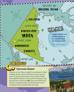
BeaUforT Sea
                                    on the map                                                                                                                                       HersCHel islanD


                                                                                                                                         W           N


            The Yukon is the farthest west of Canada’s three territories.                                                                              E
            It covers 482,443 square kilometres. The territory shares its                                                                  S                          olD Crow
            southern boundary with British Columbia, and its western
            boundary with Alaska. In the north, it meets the icy Beaufort
            Sea. In the east, the Yukon’s boundary with the Northwest                                                                                           YukOn river
            Territories follows the divide between the Yukon River and                                                                                                                                ha, ha!
                                                                                                                                                          Dawson City
            Mackenzie River watersheds.

            Most of the settlements in the Yukon are found in the                                                                                                                                          I didn’t think we
            southwest. This part of the territory can be easily reached                                                                                    yukon                                           could travel so
            from the ocean, or by roads leading from British Columbia.                                                                                                                                     far north. Then
            It takes about 30 hours to drive from the capital, Whitehorse,                                                                          MouNt lOgan                                            my friend said,
            to Vancouver, the largest city in British Columbia.

                                                                                                                                                wHiteHorse                                                 “Oh, yes, Yukon!”


                                                CANADA                                                                                                        CarCross


                              B E AU FO R T   S E A
                                                                                                                                                          WatSon lake
                                                                 Ba f f i n   Bay
                                                                               gr e e n l a n d                                         detoUr

                      YUKON
                     W H I T E H O RS E  NORTHWEST                    I QA LU I T
                                TERRITORIES   NUNAVUT                                                                                             Carcross Desert
                                       Y E L LO W K N I F E                                  LA B RA D O R   S E A
                                                                                                                                      Visitors to the Yukon might be surprised to find
                                                                                  NEWFOUNDLAND
                     BRITISH                             H U D S O N   B AY        AND LABRADOR                                       a desert there. Carcross Desert has an area of
                    COLUMBIA ALBERTA                                                            S T.   J O H N ’S                     only 2.6 square kilometres and is often called
               PAC I F I C      E D M O N T O N  MANITOBA                                                                             the smallest desert in the world. The desert was
               O C E A N
                                   SASKATCHEWAN                                                                                       formed from sand and silt that once laid at the
                    V I C T O R I A                                   QUEBEC PRINCE EDWARD ISLAND
                                         REG I NA          ONTARIO                      C h ar lot t e town                           bottom of a glacial lake. Sand also blows into
                                                W I N N I P EG         QU é B E C   C I T Y  Fr e d eri cto n  NOVA SCOTIA
          6                                                             O T TAWA  NEW    H a li fax                                   the desert from nearby Bennett Lake.                                                          7
                                   u n it e d   stat e s   o f   a m eri c a  BRUNSWICK
                                                                     T O RO N T O
                                                                                          AT LA N T I C   O C E A N