
Page 8 - My FlipBook
P. 8
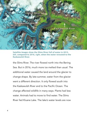
Slims River


                         Kaskawulsh Glacier


                                                                     Kaskawulsh River


                       Satellite images show the Slims River full of water in 2015,
                       left, compared to 2016, right, when the water rerouted to the
                       Kaskawulsh River.


                       the Slims River. The river flowed north into the Bering

                       Sea. But in 2016, much more ice melted than usual. The

                       additional water caused the land around the glacier to


                       change shape. By late summer, water from the glacier

                       went a different direction. It only flowed south into

                       the Kaskawulsh River and to the Pacific Ocean. The

                       change affected wildlife in many ways. Plants had less


                       water. Animals had to move to find water. The Slims

                       River fed Kluane Lake. The lake’s water levels are now


                6


          ABD_CLIM_STDY_FPGS.indd   6                                                             4/24/20   11:59 AM