
Page 9 - My FlipBook
P. 9
Exploring
Exploring The St. Lawrence River was His first trip to North America revealed
many things to Champlain, such as the
New France
New France navigation for early European a strange landscape. Despite this,
the main Canadian river of
difficulty of making his way through
explorers and fur traders.
in his first few short months in the
wilderness, Champlain created a map
of the great “rivière du Canada.” It later
became known as the St. Lawrence
Champlain was very interested in the River. When he returned to France in
geography of New France. He learned about 1603, Champlain presented his map
its many rivers and lakes from the Indigenous to King Henry IV. He also told the
Peoples who had lived on the land for king fascinating stories of the
thousands of years. On his first journey to the wild land, its peoples, and riches.
Saguenay area, Champlain was told of a large Encouraged by Champlain’s
body of salt water to the north. It would later exciting stories and records, the
be named Hudson Bay. Champlain travelled king decided to pay for another
into the interior as far as Hochelaga, although trip to New France. Within months,
today historians do not agree on the location Champlain crossed the ocean to
of Hochelaga. From his Indigenous guides, North America once more.
Champlain learned of the Great Lakes. The September 20
guides told him how he could travel far into 1603
the North American continent through this Cartography in
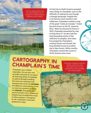
network of lakes and rivers. Champlain mapped coastlines,
Champlain’s Time islands, and rivers using
information from his own
Champlain explorations and knowledge
returns to France. Champlain was a skilled from other people.
mapmaker. He was also very
accurate, because he was good
at observing detail. Knowledge
Hudson Bay November he gained through travelling
SAGUENAY 1603 measurements from his astrolabe.
the land was combined with
St. Lawrence River Champlain publishes used information from Indigenous
He added his observations of the
Tadoussac sun and star positions to figure
out latitude. Champlain also
an account of his
Peoples and consulted the maps
ou Voyage de
Great travels, Des sauvages, of other explorers. Throughout
his life, Champlain continually
Lakes Hochelaga Samuel Champlain, updated his maps.
de Brouage.
8 9